Sunday, June 30, 2024

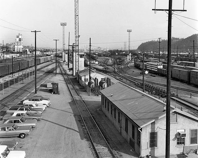
Taylor Yard, Los Angeles


1966, View of Southern Pacific Taylor Yard, looking south. Elysian Heights is visible on the right side of the photo and San Fernando Road is at the extreme left. The Purina Chow checkered mill is visible on the left side of the image. (William Reagh Collection)  https://buff.ly/4eZYJUa.  Thanks to the LAPL.

Compare the Taylor Yard pic above to this shot of the Cornfield Yard closer to Chinatown.
This shot of the Cornfield Yard you can see downtown, whereas the view of DTLA from Taylor Yard is blocked by Elysian Park.  

1964, Southern Pacific's Los Angeles freight yard, adjacent to Chinatown, N. Broadway, and the Civic Center. Workers can be seen in the foreground, unloading lumber onto a truck. (William Reagh Collection) https://buff.ly/4cWmU4k.  

The photos along with the captions come from Water and Power.  

1936, View showing a locomotive wheel change in the shop.  
Photograph caption dated January 27, 1936, reads, 
Passenger Engine No. 7856 of the Union Pacific rolled into the Los Angeles shops for a new set of tires.  Workmen at the shops lifted the 200-ton locomotive from its wheels.  August C. Roepke, mechanical supervisor, second from right, signals crane operator while J. H. Sinnar, foreman of the shop, extreme right, oversees operations and makes certain that workmen are careful and in the clear in case of accident.
1953, View of the roundhouse in operation at the Southern Pacific Taylor Yard, Los Angeles, CA.
The photograph caption, dated April 18, 1953, reads, This is the Southern Pacific's old roundhouse near the Los Angeles River.  It's a far cry from Dieselvill, which is a sprawling yard.  In the roundhouse, locomotives are stacked in stalls like silver stallions.  On the turntable is the Dinky, a snubnosed beetle on an engine which pushes the "biggies" hither and yon.  'There still is romance in steam,' said one veteran railroader.
1940, View of Railroad men on top of a boxcar learning hand signals at the Southern Pacific Yard.


1937, Southern Pacific Coast Daylight, engine number 4410, engine type 4-8-4,  Photographed by Otto Perry on July 27, 1937.
The Coast Daylight was a passenger train run by the Southern Pacific Railroad between Los Angeles and San Francisco, California.  The train ran on SP's coastline tracks which were considered to be the most beautiful route of all their passenger trains.  The passenger cars and locomotive were painted red, orange, and black.  The colors were so striking against the California coastline that the train was often called the "Most Beautiful Train in the World."  
The streamlined daylight began running on March 21, 1937.  Initially, 12 Pullman passenger cars were hauled by GS-2 steam locomotives.  Later, more passenger cars and newer steam engines were added as ridership increased.  A southbound train in San Francisco (Train 98n and a northbound train Los Angeles (Train 99) would leave at the same time.  Both would depart at 8:15 a.m. and arrive at their destination at 6:00 p.m. traveling 471 miles in 9 hours and 45 minutes.
After the inaugural run, the Coast Daylight became very popular and ridership skyrocketed.  Within a few years, the Coast Daylight had the highest ridership numbers in the country.  Almost every day the trains operated at full capacity.  SP placed in order for more streamlined cars, and when they received the new equipment in 1940 they turned the Coast Daylight into the Morning Daylight, which ran with 14 cars.  The older 1937 cars from the Coast Daylight became the mid-day train called the Noon Daylight.  Also, streamlined was the Sunbeam (Texas Daylight), the San Joaquin Daylight which ran through California Central Valley between Oakland and Los Angeles, and the Lark, which ran between San Francisco and Los Angeles at night.
1940, Southern Pacific Noon Daylight, engine number 4428, engine type 4-8-4.  Photographed in Los Angeles, CA on August 1, 1940.
The Noon Daylight was introduced on March 30, 1940, due to demand for travel on the morning Coast Daylight (San Francisco to Los Angeles), however, people preferred the earlier arrival times of the Morning Coast Daylight and patronage did not meet expectations.  The Noon Daylight was discontinued for the World War years, and not reinstated until April 14, 1946.
In the 1950s, train ridership started to decline.  More people were driving cars, flying with the airlines, or even riding rival passenger trains like the Santa Fe.  On January 7, 1955, the steam era ended for the Coast Daylight, and all trains were pulled by diesel engines though the diesels were more efficient, popular opinion felt they just did not have the appeal of a steam engine.
As ticket sales continued their downward spiral, the Daylight trains became shadows of what they had once been, giving way to shrinking and consistently Spartan amenities whenever possible.  The trains were discontinued by the SP. 
1940, Southern Pacific Sunset Limited, engine number 4414, engine type 4-8-4, photographed in Los Angeles by Otto Perry on August 1, 1940.
In 1940, the Sunset was an overnight train SF to LA that continued to New Orleans.  The SF to LA part ended 1942.
The Daylight, Southern Pacific’s original train that later became an entire fleet, was one of the most successful and recognized streamliners of all time even, rivaling the Santa Fe’s legendary Super Chief.  Interestingly, however, only one was a long distance train as the rest were regional runs which served several different Californian cities. The popularity of the train remained incredibly high for many years even through the early 1960s.  However, by the latter half of that decade the Southern Pacific began greatly reducing services and amenities on its fleet as patronage declined.  By that time the railroad grew increasingly disinterested in operating passenger trains resulting in its fabled Daylight fleet coming to an unceremonious end in the early 1970s. Today, a version of this successful fleet of trains remains under Amtrak as the popular Coast Starlight.^

Switchyard Taylor Yard.


1955, View of the shop at Southern Pacific's Taylor Yard with two SP power units and a Union Pacific car on the left.  
1950, View of Taylor Yard showing cars speeding by as the humpmaster [here (5 mins) and here] watches from his tower.

Taylor Yard (Cypress Park)


I wish I knew what year this is. That is Taylor Yard (Cypress Park) looking towards Frogtown and Dodger Stadium. I grew up on Division Street by Super A Foods and recognize that area [quite] well.  Thanks to It's All About NELA Baby.

You can see in the map below that Glassel Park is outlined.  It's off the Glendale Freeway (2), and Cypress Park, just below it, is squeezed between the 5 Fwy and the Pasadena 110 or Arroyo Seco, 110.  Atwater Village is east of the 5 Fwy, east of Los Feliz.  

Traffic on Fletcher Drive under the Pacific Electric Railroad, 1938

1938, #Cars drive under the Pacific Electric railroad tracks crossing #FletcherDrive.  Thanks to It's All Abou NELA Baby.


Watts Riots & LA City Jail, Lincoln Heights, 1965

Above is the Lincoln Heights Jail, located at 421 North Avenue 19, Los Angeles, CA.  The Jail opened in 1931 and closed in 1965.  It is today #587 on the list of Los Angeles Historical Cultural Monuments on the East and Northeast Side, meaning that it still stands but serves as what, a museum?  

National Guardsmen during the #WattsRiots. In front of #LincolnHeightsJail. August 16, 1965. 

1936, Los Angeles City Jail at 419 North Avenue 19 in Lincoln Heights.  Thanks to Los Angeles Relics.  Posted on Saturday, September 7, 2024.

LA County Jail is located at 441 Bauchet St, Los Angeles, CA 90012.  See map.

Monte Sano Hospital, Los Angeles, CA 1933.

View of ex-PE MCL PCC car, outbound at Monte Sano, Los Angeles, CA, 1954


Monte Sano was California's first osteopathic hospital, built in 1923 and closed sometime in the 1970s. According to The Merger M.D.s & D.O.s in Early California, Monte Sano was "envisioned as the perfect recuperation resort on its hill of health."
It was located at 2834 Glendale Blvd. (at Waverly), Silver Lake.

I have no information on this photo yet other than it was identified [at the center-right of the photo] as the Monte Sano Hospital in Glendale. 

Saturday, June 29, 2024

St. Paul's Episcopal Church, Central Park [aka, Pershing Square], 1913


1913, In this beautifully crisp photo, we’re looking southeast across downtown Los Angeles past St. Paul's Episcopal Church, which is the one with the pointy tower. Past it, that expanse of trees is what we now know as Pershing Square. This photo is from 1913, so it was then still known as Central Park. But the detail that catches my eye is that pale building down in front – the “Young Women’s Boarding Home” which I had never heard of before. It stood at 514 S. Grand Ave, and was run by the Salvation Army, and was torn down to make way for L.A.'s Biltmore Hotel, which opened in 1923. It looks to be quite a large place and has me wondering if it housed any young and independent women who eventually made it into the flickers. I have a second photo taken that day on my website:  https://wp.me/p5XK3w-7yn Thanks to Martin Turnbull.  


8th Street and Vermont Ave on September 8, 1950: post-war dismantling of LA’s extensive streetcar network

1950, If what’s going on in the photo is what I think is going on, it’s a bit of a sad day, if you ask me. We’re looking toward the northeast corner of 8th Street and Vermont Ave on September 8, 1950. Those workmen look like they’re ripping up streetcar tracks, which means what we’re seeing is the beginning of the post-war dismantling of LA’s extensive streetcar network. For most of its existence, the streetcars failed to break even, much less make a profit, but gosh, wouldn’t it be nice if we’d found a way to retain them as a valid way to get around Los Angeles?  Thanks to Martin Turnbull.

Pantages Theatre (then still the “RKO Pantages”) the night that the 28th Academy Awards were held on March 21, 1956

I saw The Lion King here back in 1995.  Oy.

1956, The shot above is of the Academy Awards held here in 1956.  Thanks to Martin Turnbull for this pic.  Caption reads,

I count six spotlights crisscrossing Hollywood Blvd outside the Pantages Theatre (then still the “RKO Pantages”) the night that the 28th Academy Awards were held on March 21, 1956 to honor the films of 1955. This was the year that “Marty” picked up Best Picture, Director, Actor, and Screenplay. In the background, we can see the neon sign for Hody’s diner on the northwest corner of Hollywood and Vine. I wonder if they did a roaring trade that night after all the celebrities had gone in and the movie fans packing the Hollywood Blvd sidewalk had dispersed. 

All reacti

2 LA Times Buildings in 1 Shot, 1934


1934, We get two L.A. Times buildings for the price of one. The street on the right with the streetcars is Broadway, and we’re looking south from First Street. The building on the left with the tower that looks like it was born in a 15th-century British castle is the building that the Times occupied until their new building was ready for occupation. We can see the Times’ new building behind it; it’s still under construction (is it Streamline Moderne?) and would open the following year. I wonder, however, where was this photograph taken from? A low-flying airplane seems unlikely.  Thank you to Martin Turnbull.  Some decent pics of the Times Building here.

1925, Civic Center.  Panoramic view of the Civic Center in the 1920s, looking north from First and Broadway, with the old Los Angeles Times Building in the foreground and the Hall of Records, the old County Courthouse, and the Broadway Tunnel beyond.   

TRAVELOGUE TITLED, "LOS ANGELES" 1916, CREATED BY FORD MOTOR CO. & EDISON CO. LOS ANGELES, CALIFORNIA

This film is housed at Periscope Films.  You can search the search window there for anything about LA and might find some interesting videos.

3:58  Pershing Square.  Nice ground shots of Pershing Square at the 3:58 mark.  In 1916, Pershing Square was called Central Park, like New York's.  

4:57  Angel's Flight.  
  
6:09  Chinatown.

6:55  The Old Plaza. 


8:14  Scottish Rite Temple.  

9:43  California Aqueduct.

10:29  California Bungalows.  1916 California Bungalows are today's mansions.  

11:50  California's Oil Fields.  Oh, boy.  Signal Hill, all the beach areas, et al.

12:23  Broadway and the fashionable shopping district. 

13:00  Catalina Island.  And a departure from LA looks like it's out of San Pedro, to Catalina at 13:38.  

14:39  This clip appears for only an instant at the 14:39 mark. 


It's funny because every city needs to market its virtues by comparing itself to some more magnificent world landmark.  In this case, it's the Great Wall of China.  It reads, 
The breakwater rivals the ancient wall of China, being two hundred feet thick at the base, sixty-eight feet high and two miles long--a tribute to the Gentle Pacific. 

The Hotel Metropole was the big draw in Avalon, Catalina back in the day.  

14:52  Hotel Stamford.  Find this shot below at about 4/5 down the page at Water and Power.

The caption from the Water and Power site reads, 
1920s. View showing the west side of the 100 block of Metropole Avenue in Avalon.  Pictured are the Hotel Stamford, Catalina Hardware Company, the Hermosa Hotel and Cottages, and the Boos Bros Cafeteria on the right with the multiple streetlamps in front. 

By the way, that Water and Power page has some fantastic shots of Catalina from back in the 1920s.  

17:49  South Spring Street.  Okay, I'll bite.  What was South Spring Street known for in 1916?  The film does not say.

19:15   Orange Groves.  The Fish Canyon area of Duarte was nothing but orange groves before our tract was built.  The footage here in this segment of the film is uneventful.

20:04  Picking Oranges.  O, the excitement.  

20:50  Building a Harbor at San Pedro.


Friday, June 28, 2024

Hill Street Tunnels between Temple and First Streets, 1928-1955

The following photos come from Water and Power.  

1928, Hill Street Tunnel, Los Angeles, CA.  Thanks to Muskan Khan.

1940, Three elderly gentlemen socialize on a bench on top of the Hill Street Tunnel, looking south.  The intersection seen below at street level is where 1st Street (only partially visible) meets Hill Street.  Cars and street cars are seen traveling north and south.  

1945, Looking south from Temple through the streetcar side of the Hill Street Tunnel which was bored through a part of Bunker Hill in 1909 by Los Angeles Pacific (a predecessor of Pacific Electric).  It connects Hill Street from First to Temple.  A "Private Way for Trains" sign is above the tunnel.  Apartment houses are seen at the top of the hill.  

1945, Small businesses and dilapidated hotels and apartments are in this view looking north from the top of the Hill Street Tunnels.  A Pacific Red Car stops for passengers.  A billboard for "Rice Krispies" with its "Snap, Crackle, & Pop," right, is in front of the Temple-Hill Hotel.  Center, a billboard for "GMC Trucks" borders a parking lot.  At the back of the lot is a billboard for "Eskimo Pie."  A man climbs the stairs at the side of the tunnel.  The broken balustrade on top is held together by a wooden frame.  

1945, Looking south from Temple at the Hill Street Tunnels.  Streetcar traffic uses the right tunnel, a "Private Way for Trains" sign is on top, and automobiles the left.  Passengers wait on benches for the Pacific "Red Line" streetcar.  The parking lot on top of the tunnel is full.  Palm trees sit in front of the apartment houses on top of the hill.  

1948, Looking southwest from Temple Street towards the Hill Street Tunnel (half visible), where two Pacific Electric Railway cars are seen traveling north.  Office buildings are seen on the right and a few boardinghouses are present on the hillside. 

1949, View of a streetcar running inbound on the Hollywood Boulevard streetcar line emerging from the southern portal of the Hill Street Tunnel at 1st Street.  Note the apartment buildings on the southwest corner of Hill and 1st Street.

1953, A head-on view of the Hill Street Tunnels, looking north from First Street, shows a man crossing the street.  Two Victorian houses sit on the hill behind the tunnel portals at the top right, with a parking lot visible on the northeast corner of Hill and 1st Street. 
1953, Self-portrait of Arnold Hylen leaning on the railing above the south portal of the Hill Street Tunnel.  Trees and a stairway are visible behind him.  City Hall can be seen to the right.  

1953, The #11  Temple Street bus enters the north portal of the Hill Street Tunnel heading south. 

1953, Looking northeast across the intersection of West First (foreground) and North Hill streets (running diagonally from left to lower right), showing the Los Angeles County Law Library (right), the Law Building at 139 N. Broadway, and the bridge to its parking lot (upper right and center) and the south portal of the Hill Street Tunnels is seen on the left.

1954, Panoramic view showing the Hill Street Tunnels during the early stages of demolition.  Note the tunnel was still open to traffic during the tunnel's demolition.   

1954, Hill Street Tunnels (north portal) seen from Temple Street at night, a great film noir look.  The tunnels connected Hill Street from Temple to 1st Street.  Photo by LA Times on October 12, 1954.
1954, Demolition begins on the Hill Street Tunnels.  The view is looking north at Hill and 1st Street.
1954, Temple Street looking west with the Hill Street Tunnels (north portals) in view.  


1955, View of the side-by-side Hill Street Tunnels, looking north from 1st Street.  Two autos and a bus are exiting the left side tunnel, even though the entire surroundings have been demolished, in preparation for future buildings.  Photograph dated May 10, 1945.  Photo by D. R. Perkins.

Thursday, June 27, 2024

Sixth Street Viaduct, 1932

November 9, 1932, this view of Sixth Street Viaduct was taken from the west bank of the Los Angeles River. Thanks to Los Angeles Relics.

Thanks to Water & Power for the following shots of the 6th Street Bridge. Construction of the Bridge began in 1932.


1931, A few workers scattered along the wooden forms on the eastern side of the bridge. October 27, 1931. | Courtesy of the Los Angeles City Archives' Special Collections, Office of the City Clerk.  From PBS So Cal.

1935, Downtown Los Angeles from the 6th Street Bridge.  Thank you to Los Angeles Relics