Saturday, August 31, 2024
Ship being loaded at Los Angeles Harbor, 1987
1987, View of a ship being loaded at Los Angeles Harbor, with cranes placing bins onto its deck. In the foreground, two wooden piers are visible, while the Vincent Thomas Bridge can be seen in the distance. Photo by William Reagh. Thank you to Jack Feldman. More pics of the bridge, the harbor, marinas, etc., thanks to Water & Power.
Thursday, August 29, 2024
9th Street, Spring Street, and Main Street, 1930
1930, Looking north from 9th Street where Spring Street (left) and Main Street (right) split. Thank you to LAPL.
KFI Radio Station, 1929
1929, Exterior view of KFI radio station, located at 1000 South Hope Street. The synagogue, B'nai B'rith, is visible in the background on the left on the corner of 9th and Hope Streets. Thank you to LAPL, LA Public Library.
Jim Hilliker gives us a nice little history,
KFI and KECA were on the top of the Packard dealership building, owned by Earle C. Anthony, California distributor of Packard motor cars. KFI started in 1922 while KECA was established November 15, 1929. They continued broadcasting here until December 1939. ECA purchased KEHE radio from Hearst Radio, and KEHE 780 became KECA. KFI and KECA took over the former KEHE studios at 141 N. Vermont in 1939. In 1944, KECA was sold to ABC and became KABC 790 in 1954. KFI radio was at 141 N. Vermont until 1975. ECA also owned KFI-FM and KFI-TV channel 9 between 1948-1951.
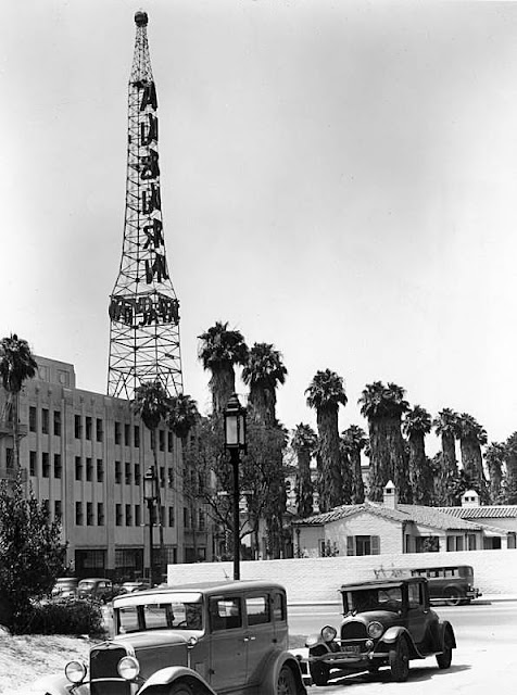
1930s, Looking towards Auburn Carl Broadcasting, KFVD radio station, located in the Miracle Mile at 5900 Wilshire Boulevard. Thank you to LAPL.
4th & Spring Street
1912, The United Cigar Company's store on 4th and Spring Streets, 1912. Electric companies actively marketed outdoor lighting to retailers to increase demand for electricity. Thank you to LA Relics and the Huntington Library.
Saturday, August 24, 2024
Sylmar Earthquake, 1971
1971, View of the Golden State Freeway at Tuxford, closed, due to pavement torn up in many locations by earthquake. (Bob Steiner - Herald Examiner Collection) https://buff.ly/3MQBGhr. Called the Sylmar Earthquake of 1971.
Saturday, August 17, 2024
Steven M. White, 1960
1960, The short version, Steven M. White statue originally stood on the lawn of the old Sandstone County Courthouse ending up in a utility yard for many years . . . brought back to life at the L.A. Courthouse on the N.W. corner of Hill & 1st. It now stands at the entrance to Cabrillo Beach in San Pedro. Thanks to Mark Frazier. Mark adds that,  1960, State Office Building No. 2, Broadway & 2nd St., Los Angeles, 1960. Thanks to USC Libraries. The caption reads,
In this photo, it's State Office Building #2... today, it's a U.S. Courthouse (the big glass cube) taking up most of the whole block between Broadway & Hill & 1st & 2nd Streets!
However, that Calisphere link gives the date as 1960. The Calisphere caption shines a little more light on the building,
Photograph facing due west of the new State Office Building No. 2. "New $10,775,000 home for 26 state government branches. -- It stands at First Street and Broadway. Early-day Senator White's statue at right." -- Examiner clipping attached to verso, dated 27 November 1960.
 1960, State Office Building No. 2, Broadway & 2nd St., Los Angeles, 1960. Thanks to USC Libraries. The caption reads,
 Photograph of the new Office Building No. 2 at the corner of Broadway and Second Street, facing north. The sign in the front of the building reads "State of California Office Building No. 2, State Division of Architecture." "New State Office building an example of economy. Legislature cut out the frills, kept the costs down." -- Examiner clipping attached to verso, dated 17 April 1960.; Streetscape. Horizontal photography.
Black Building, 1948
1948, Black Building 4th and Hill Street. The Black Building was a modern, 11-story office building at the time of sale to a group of Los Angeles businessmen.
1947, Photograph of the Black Building, corner of 4th Street and Hill Street, downtown Los Angeles. Drug store on the ground floor encourages customers to "visit our fountain". "Received Examiner reference library: Jan. 27, 1947" -- stamped on verso.
Friday, August 16, 2024
The Minnewaska Hotel, also known as the Dome, 1964
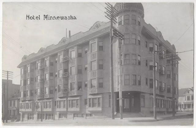
1909, Hotel Minnewaska. This is a vintage post card of the hotel found on eBay.
1964, The Minnewaska Hotel, also known as the Dome, is located at 201 S. Grand Avenue with furnished apartments for rent. Thanks to LAPL and from the Photo Collection @ LAPL.1964, Profile view of "The Dome" shortly before a fire destroyed the building.
1963, View looking south on Grand Avenue at 1st Street with the Dorothy Chandler Pavilion, right, and the LA County Courthouse, left. In the distance can be seen the AT&T Madison Complex Tandem Office Building and the Dome Hotel and Apartments.
On the morning of July 25, 1964, the Dome burst into flames. [Odd how that happens so frequently during redevelopment eras.] The building would be razed later that year to make room for a parking lot which existed until 2014 when construction began for the Broad Contemporary Art Museum, completed in 2015.
1960, View showing the Dome Hotel and Apartments, previously called the Minnewaska Hotel, located on the southwest corner of 2nd and Grand Avenue. The lot to the right is the future location of the Walt Disney Concert Hall. In the background through the haze and smog can be seen the Richfield Oil Company Building, which was demolished in 1969 to make way for the ARCO Towers. Thanks to Water and Power.
1960, View looking southwest from the LA County Courthouse at 1st and Grand Avenue showing a large empty lot sitting on top of Bunker Hill. This will become the site of the Walt Disney Concert Hall, completed in 2003. The Multi-story building with the dome seen in the upper left is the Dome Hotel and Apartments, SW corner of 2nd and Grand Avenue. Today, the Broad Contemporary Art Museum stands at the SW corner of 1st and Grand. Thanks to Water and Power.
Japanese Internment, 1942
1942, Little Tokyo. View of the north side of East 1st Street, which will soon be empty as Mayor Bowron reeported the evacuation plan for Little Tokyo residents. City Hall hovers in the background and some businesses, such as the Nelson Hotel, Chop Suey Cafe, Nanka Shu Hotel, Hori Bros., and the Rainer Cafe, are visible on the street, which reveals various cars and some Pacific Electric streetcar tracks. Dated March 21, 1942. The full caption reads: Los Angeles, California. Street scene in Little Tokyo near Los Angeles Civic Center, prior to evacuation of residents of Japanese ancestry. Evacuees will be assigned to War Relocation Authority centers for the duration.
1942, Shops for rent on a deserted 1st Street in Little Tokyo on June 18, 1942, following the evacuation of Japanese American residents to internment camps. (Herald-Examiner Collection) https://buff.ly/4dhjHgd.
1942, Vacant and deserted business houses along 1st Street after the evacuation of Japanese people during World War II. Thanks to Water & Power.
1942, View showing Japanese men, women, and children boarding trains and buses as they started their journey at the old Santa Fe Station to Manzanar Internment Camp in Owens Valley.
The Japanese American internment during World War II affected about 110,000 people of Japanese heritage who lived on the Pacific coast of the United States. The U.S. government ordered the internment in 1942, shortly after Imperial Japan attacked Pearl Harbor. The internment of Japanese Americans was applied unequally as a geographic matter: all who lived on the West Coast were interned, while in Hawaii, where 150,000-plus Japanese Americans comprised over one-third of the population, only 1,200 to 1,800 were interned. 62% of the internees were American citizens.^*
Wednesday, August 14, 2024
Los Angeles Flood of 1938
Be sure to check out this list of photos that you may not have seen before. Thank you to the Vintage News. Wikipedia, too, offers decent pics and videos of the 1938 flood across Southern California.
1938, The Los Angeles flood of 1938 was responsible for inundating much of Los Angeles, Orange, and Riverside counties, California during February and March 1938. The flood was caused by a pair of Pacific storms that swept inland across the Los Angeles Basin, causing abnormally high rainfall across much of coastal Southern California. Rivers overflowed and dozens of people were killed. Local government agencies responded by turning the Los Angeles River into a flood control channel. When the storm ended on March 3, the resulting damage was huge. March 2, 1938: Floodwaters in the Los Angeles River destroy Southern Pacific railroad bridge. The photo was taken from North Figueroa Street bridge. Feb. 28, 1938: Autos stall in flooded Fox Hills Boulevard and Slauson Avenue after the first storm brought about 4 inches of rain. March 1, 1938: A three-story structure once occupied by a cafe at Cheeney Road and Topanga Canyon Road collapsed and toppled into the highway as prolonged rains softened foundations. March 2, 1938: Flooding at West 43rd Place near Leimert Boulevard. March 2, 1938: Flooding at West 43rd Place and 11th Avenue near Leimert Boulevard stranded a school bus. March 2, 1938: A mudslide at Harper Avenue and Sunset Boulevard caught this automobile and closed the area to traffic. March 2, 1938: A washed-out bridge at Colfax Avenue over the Los Angeles River in Studio City. March 2, 1938: Firemen search for the body of Ruth Randall, 28, and son Leonard, 6, after their home was destroyed by a landslide on the 1900 block of Landa Street. March 2, 1938: A salvage crew tries to dig out a gravel truck damaged by flooding along the Los Angeles River. The truck was at a construction project to build a railroad crossing for Union Pacific across the river. March 2, 1938: Water rising above the drain level in underground conduits threatened telephone service in downtown Los Angeles. Fire Department pumpers answered the call. March 2, 1938: Dr. A. J. Gray, left, Douglas Dawson and Dr. A. G. Hobbs do a little fishing at home on 500 block of South New Hampshire. March 2, 1938: Drains could not keep up with rain filling streets in downtown Los Angeles. March 2, 1938: Water-soaked earth moved rapidly down the side of Laurel Canyon at Kirkwood Avenue, carrying trees and boulders in its path and wrecking the basement garage of this home. March 2, 1938: Hugh Beckly stands atop a car almost covered by water at 6th Street near June. Arden Day cruises by in a skiff. March 3, 1938: William L. Griffin digs out the family car on the 1700 block of Fernlane Street as Lloyd Griffin and David Stagg watch. March 3, 1938: The family of J.E. Webb in Venice is rescued by boat, and two children with mumps were sent to a hospital. March 3, 1938: The La Canada Street Bridge over Verdugo Wash near junction of Verdugo Road. The bridge, a WPA project, was under construction when the storm hit. March 3, 1938: Milkman Ray J. Henville secured himself a boat and boatman and made all deliveries on time and on doorstep. March 3, 1938: The washed-out Santa Fe Bridge over the Arroyo Seco paralleling Pasadena Avenue Bridge. March 3, 1938: These ruins were once a residence on the 2000 block of Los Encinos Street, Glendale. Two men met their death when the house collapsed into the street. Workmen search for the bodies. March 3, 1938: Floodwaters flow slowly through the steets of Venice after a major storm. March 4, 1938: A road crew removes debris from Foothill Boulevard at Lowell Street near Tujunga. March 4, 1938: A railroad crane was set up for bridge building work over the Los Angeles River near Avenue 19. March 5, 1938: Henry Cooper with a dog and rooster, all that was saved from Earl Callan's home, part of which can be seen in the Los Angeles River in the background. Cooper was the caretaker for the destroyed home in the 1700 block of Riverside Drive. March 5, 1938: Heavily traveled Riverside Drive in Glendale was undermined by the torrent of the Los Angeles River. This damaged section was near the former Grand Central Airport. March 7, 1938: A portion of Roosevelt Highway (now Pacific Coast Highway) at Santa Monica Canyon is repaired after heavy rains on March 1. March 7, 1938: Mr. and Mrs. J. L. Smith, their daughter and 5-year-old granddaughter at Burbank and Ethel Streets in Van Nuys begin the task of digging out their home. March 7, 1938: Los Angeles city engineering crews fill in a 300-yard section of Ventura Boulevard near Laurel Canyon Drive that was gouged out by the swollen Los Angeles River on March 1. March 6, 1938: Ruth Curry, with a broken arm, owner of Camp Baldy resort, stands in front of shattered cabins after floodwaters destroyed the majority of them. In a 36-hour period starting on March 1, 14.78 inches of rain fell. March, 1938: Wreckage piled up in front of the Camp Baldy garage. Workers repair a telephone pole. No other information was available. A boulder on a road after a rainstorm on March 1, 1938. The car may be the photographer's vehicle; no other information was available. March 1, 1938: Flooding in Culver City. March 2, 1938: Mrs. L. Swink put on her swimsuit as she moved out after flooding. March 2, 1938: About 10 people drowned when they were swept into the Los Angeles River after the collapse of the 3rd Street pedestrian bridge in Long Beach. One person was rescued by the battleship Utah, at anchor three miles offshore. (Photographs by Los Angeles Times). Thank you to Vintage Everyday.
1938, The Los Angeles Flood of 1938 was responsible for inundating much of Los Angeles, Orange, and Riverside counties, California during February and March. You can where this is located, La Crescenta, CA along the San Gabriel Foothills. Thank you to the Vintage News.
Monday, August 12, 2024
Downtown Los Angeles, 1980
1930, The California Club. is located on the east side of Flower directly in front of the UCB Building.
1950s, Bunker Hill, Los Angeles, CA. Thank you to John Nelson.
from the LA Times,
1959, The city of Los Angeles adopts the Bunker Hill Urban Renewal Project. According to Curbed Los Angeles, “The redevelopment project adopted by the city on March 31, 1959, grew out of an urban revival movement sweeping the nation and kick-started by federal housing acts that offered aid for the clearing of ‘urban blight.’” Opponents slowed it down but couldn’t stop it. “Six-thousand residents, mostly poor people and senior citizens eligible for public housing, were relocated outside of the area; the promised replacement affordable housing never materialized.”
1973, The UCB, or United California Bank Building is set farther back behind the Security Pacific Bank on the east side of Flower.
1974-1977, The Westin Bonaventure Hotel with the glassy silos at the middle right was built between 1974 and 1977.
1975, Security Pacific Bank, the tall building on the left, was built in 1975.
Bunker Hill was a dense residential neighborhood on the western edge of downtown Los Angeles.
Nathan Marsak has written a few books on Bunker Hill.
1980, Downtown Los Angeles. Donald Lehr gets us started with a caption, "Looking down Flower St. B of A, Westin, California Club . . . ."
1947, Bunker Hill.
1940, Bunker Hill colorized.
8th Street and Garland Avenue, 1938
1938, Looking Southeast Down 8th Street, from Just West of Where It Crosses Garland Avenue, Los Angeles (1938). Thank you to Los Angeles Historical USA. Posted Monday, February 24, 2025.
In 1938, 8th Street was a thriving commercial corridor in downtown Los Angeles, lined with bustling storefronts, office buildings, and streetcars. This view looking southeast from just west of Garland Avenue captured the energy of daily life, with pedestrians navigating the sidewalks and early automobiles filling the street. The mix of architectural styles, from Beaux-Arts to Streamline Moderne, reflected the city’s evolving skyline. As Los Angeles continued its rapid expansion, streets like 8th Street remained essential to the city’s business and cultural landscape, offering a glimpse into the dynamic urban life of the late 1930s.
In 1941, the intersection of 8th Street and Garland Avenue reflected the industrial and commercial vibrancy of downtown Los Angeles. Warehouses, small factories, and service-oriented businesses lined the streets. Delivery trucks and early 1940s sedans navigated the bustling roads, reflecting the era’s shift toward modern transportation. The workers and delivery drivers moving about represented the backbone of the city's economic activity. This view of 8th Street illustrated the city's blue-collar roots and its ongoing transformation into a major metropolitan hub. Thank you to Historical Los Angeles, USA.
Sunset & Spring Street [and New High Street], 1940
1940, Sunset Boulevard at Spring Street, which turns into New High Street north of Sunset. See map below. Thank you to LAPL.
Saturday, August 10, 2024
"New" Chamber of Commerce Building, 12th & Hill St. (dedicated 1924)
1924, "New" Chamber of Commerce Building, 12th & Hill St. (dedicated 1924). Thanks to Digital Library, USC.
Hollywood Knickerbocker Hotel, Opened 1925, Converted 1929
Hollywood Knickerbocker Hotel, Opened 1925, Converted 1929
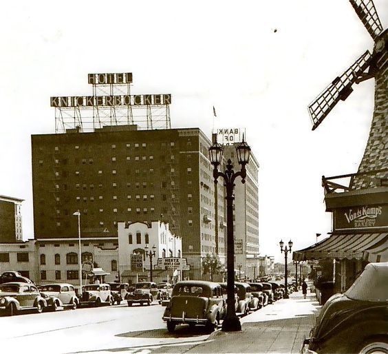
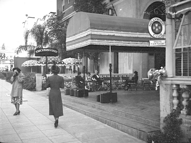
1925, The Hollywood Knickerbocker Apartments, formerly the Knickerbocker Hotel, is a senior home located at 1714 Ivar Avenue in Los Angeles, California. Built in 1925 by E.M. Frasier in Spanish Colonial. Thank you to Waldina.
from Martin Trumbull, The Knickerbocker Hotel at 1714 Ivar Ave, Hollywood. It opened in 1923 as a luxury apartment building before subsequently becoming a hotel with a slogan of “Your home for a year or a day”. It’s had quite the history, playing host to the likes of Rudolph Valentino, Elvis Presley, Marilyn Monroe and Joe DiMaggio, Frank Sinatra, Lana Turner, Mae West, and Cecil B. DeMille among many, others. On the downside, D.W. Griffith died of a stroke on July 21, 1948 under the crystal chandelier of the lobby; costume designer named Irene Gibbons jumped to her death from a hotel window; William Frawley, who lived at the hotel for decades, died of a heart attack on the sidewalk in front of the Knickerbocker. In 1970 it was converted into housing for senior citizens which it remains to this day.
1925, Opened as a luxury apartment house in 1925 and then converted to a hotel in 1929. Thanks to John Nelson.
More from Martin Trumbull,
Fleishhacker Pool, San Francisco, 1925-1971
1961, Fleishhacker Pool, San Francisco, 1925-1971. Thank you to Historic San Francisco.
Golden Gate Bridge, San Francisco, 1933, Opened 1937-
1937, Golden Gate Bridge Under Construction, San Francisco (1937)
By 1937, construction of the Golden Gate Bridge was in its final stages, drawing attention from across the nation. The bridge’s main towers, connected by cables, stretched across the bay in a magnificent display of engineering. As one of the last steps in construction, crews worked tirelessly to complete the roadbed, anticipating the bridge’s grand opening. This iconic structure, symbolic of hope and resilience, became an instant landmark upon its completion, celebrated worldwide. Thank you to Historical San Francisco, USA.
By 1937, construction of the Golden Gate Bridge was in its final stages, drawing attention from across the nation. The bridge’s main towers, connected by cables, stretched across the bay in a magnificent display of engineering. As one of the last steps in construction, crews worked tirelessly to complete the roadbed, anticipating the bridge’s grand opening. This iconic structure, symbolic of hope and resilience, became an instant landmark upon its completion, celebrated worldwide. Thank you to Historical San Francisco, USA.
Subscribe to:
Comments (Atom)

.jpg)


.jpg)


.jpg)


.jpg)

%20%20Old%20Macy%20Street%20Bridge.jpg)
.jpg)
8th%20street%20and%20garland%201938.jpg)

.jpg)
.jpg)


.jpg)

.jpg)
.jpg)


%20%20Catching%20a%20Turkey%20under%20the%20Golden%20Gate%20Bridge%20(1940s.jpg)